Posts

Showing posts from June, 2023

Web Soil Survey

Image
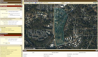
I enjoyed learning how to use the USDA's Web Soil Survey for the Blue Heron Nature Preserve. When searching for the area of interest (AOI), I initially found capturing the Blue Heron Nature Preserve difficult since the address only pinpointed the location. The  Define AOI by Polygon  tool allowed me to map out the Blue Heron Nature Preserve since it is an odd shape and does not appear on the map. As someone starting with WSS, figuring out where to create my AOI was difficult. Once I spent a few minutes playing around with the website, it made more sense to where to look for information. Here is the Blue Heron Nature Preserve documented as the AOI: Next, I utilized the  Soil Map  to see what soil/miscellaneous areas are in the Blue Heron Nature Preserve. When starting this project, I was nervous about the Soil Map, primarily because of my limited environmental background. The  Intro to Soils  page under  Soil Data Explorer  helped me learn about so...

Climate and Weather Information

Drought Monitor:   https://www.drought.gov/states/georgia The first resource I thought would be relevant is a drought monitor, since droughts can increase the chance of wildfires and change the structure of wetlands. NOAA's National Integrated Drought Information System maps out the U.S. Drought Monitor, USDM 1-Week Change Map, Short-Term Multi-Indicator Drought Index and Long-Term Multi-Indicator Drought Index. The map utilizes five classifications for their Drought and Dryness Categories: abnormally dry (D0), moderate drought (D1), severe drought (D2), extreme drought (D3), exceptional drought (D4). Since the Blue Heron Nature Preserve contains Nancy Creek and surrounding wetlands, monitoring droughts is a vital preparedness and mitigation tool.  Precipitation:  https://www.ncei.noaa.gov/access/past-weather/Atlanta%2C%20Georgia Nancy Creek runs through the Blue Heron Nature Preserve, so monitoring precipitation is also essential. NOAA's National Center for Environmental...

Google MyMaps

  I really liked using MyMaps to map out the Blue Heron Nature Preserve! The preserve is split into three areas, so the line tool allowed me to map out the areas that don't pop up on Google Maps. I currently have one layer that shows all the significant areas, but as the research continues, I can add more to show different species and habitats. It is very easy to move the pins to a different layer, which is helpful as this will be a living map!

Ecology Slides

My Definition of Biodiversity and Importance of Biodiversity

 To me, biodiversity is the study of the vast array of plants, animals, and microorganisms that makes up an area and promotes resiliency in an ecosystem. When thinking about biodiversity on a local and regional level, it provides a unique chance for unity within a community. Species that only reside at local or regional levels can cause the community to take accountability for the species, because they feel the need to protect it. These endemic species make a community more unique and could result in more protection and conservation efforts. Biodiversity is important nationally and internationally because it supports medicinal demands, climate regulation, and basic human needs; biodiversity also holds the power to grow and expand into something new as the Earth and its inhabitants evolve. On a strictly national level, a diverse biodiversity has the ability to allow the country to flourish as long as the inhabitants of the country know how to work with the biodiversity and not again...

Rationale of Choosing the Blue Heron Nature Preserve

For my project, my study area will be the Blue Heron Nature Preserve in north Atlanta, Georgia. The nature preserve includes the 3-mile Blueway Trail within 30 acres of the nature preserve; the preserve is made up of meadows, woodlands, wetlands and riparian. They have over 28 plant species and over 35 animal species, so I think it gives a lot of opportunities for investigating and documenting the biodiversity. The nature reserve also promotes certain aspects of each area: the meadows promote reintroduction of pollinators, the woodlands promote proper burning of firewood to reduce tree disease, the wetlands promote the importance of water quality and the riparian promotes runoff education. The are also has over 13 research conservation projects, including a turtle sanctuary, rain garden, Neighborhood Water Watch program and the Field Research Center Native Pollinator Garden. I think the Blue Heron Nature Preserve has a lot of opportunity to be a great source of information for this pro...