Posts
Classification and Taxonomy Refresher
https://en.m.wikipedia.org/wiki/Cricetidae Family: Cricetidae -608 species of rodents that have large, gnawing incisors, tails (furry or bald) and fur that is mostly brown with a white underbelly -Can grow from 2 inches long to 24 inches long -Weight varies from 0.25 ounces to 2.4 pounds Subfamily: Muroidea -Large superfamily of rodents that includes mice, rats, voles, hamsters, lemmings and gerbils Order: Rodentia -Rodents that have a single pair of continuously growing incisors on the upper and lower jaw Class: Mammalia -Contains mammary glands that produce milk, a neocortex region of the brain, fur/hair and three middle ear bones Phylum: Chordata -Contains a notochord, hollow dorsal nerve cord, endostyle/thyroid, pharyngeal slits and a post-anal tail at some point during their larval/adult stage Kingdom: Animalia -Multicellular, eukaryotic organizations that consume organic material, breathe oxygen, contain abili...
Audubon Bird Guide Review

This week, I reviewed the Audubon Bird Guide in relation to the Blue Heron Nature Preserve. When I first opened the app, I liked that it had the Get to Know 20 Common Birds guide. As someone who is not too familiar with the birds in my area, it was nice that the app allowed beginners to get a good footing in bird sightings. On the main page of the app, it also has the capability to identify a bird by characteristics (size, color, type, activity, habitat, voice, wind shape and tail shapes) or by searching the bird's name in the guide. This allows beginners and experts to identify birds based on their own skill sets. On the Explore page of the app, the map allows you view Hotspots with pings of recent bird sightings in the area. The Agnes Scott College Hotspot (below) shows the date, time, species and amount of sightings. I like that the sightings show clear images that would make it easy for me to start recognizing these birds in my neighborhood. If you press on one of ...
Web Soil Survey
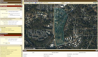
I enjoyed learning how to use the USDA's Web Soil Survey for the Blue Heron Nature Preserve. When searching for the area of interest (AOI), I initially found capturing the Blue Heron Nature Preserve difficult since the address only pinpointed the location. The Define AOI by Polygon tool allowed me to map out the Blue Heron Nature Preserve since it is an odd shape and does not appear on the map. As someone starting with WSS, figuring out where to create my AOI was difficult. Once I spent a few minutes playing around with the website, it made more sense to where to look for information. Here is the Blue Heron Nature Preserve documented as the AOI: Next, I utilized the Soil Map to see what soil/miscellaneous areas are in the Blue Heron Nature Preserve. When starting this project, I was nervous about the Soil Map, primarily because of my limited environmental background. The Intro to Soils page under Soil Data Explorer helped me learn about so...
Climate and Weather Information
Drought Monitor: https://www.drought.gov/states/georgia The first resource I thought would be relevant is a drought monitor, since droughts can increase the chance of wildfires and change the structure of wetlands. NOAA's National Integrated Drought Information System maps out the U.S. Drought Monitor, USDM 1-Week Change Map, Short-Term Multi-Indicator Drought Index and Long-Term Multi-Indicator Drought Index. The map utilizes five classifications for their Drought and Dryness Categories: abnormally dry (D0), moderate drought (D1), severe drought (D2), extreme drought (D3), exceptional drought (D4). Since the Blue Heron Nature Preserve contains Nancy Creek and surrounding wetlands, monitoring droughts is a vital preparedness and mitigation tool. Precipitation: https://www.ncei.noaa.gov/access/past-weather/Atlanta%2C%20Georgia Nancy Creek runs through the Blue Heron Nature Preserve, so monitoring precipitation is also essential. NOAA's National Center for Environmental...